Györgyi Gábor: Bicycle tours in the French Alps - indulging in nostalgia
GÁBOR GYÖRGYI
Nostalgic bicycle tour in the French Alps and collecting paved roads going above 2000 m
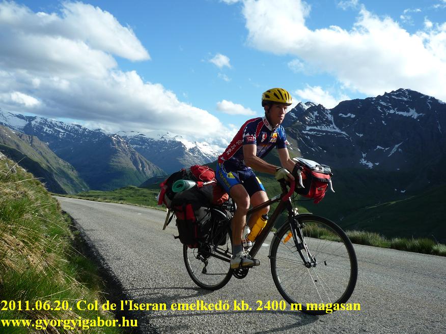
10-22nd June, 2011. (13 days): 1530 km + 28989 m height difference
Introduction:
I started bicycletouring by the age of 16-17 with 3-6 day long tours in Hungary. Later I had 5 bicycle tour to the High Tatras and back, then I turned my handlebars towards the Alps first in the year 2000. In that year I cycled few days in the Dolomites, where from I pushed the pedals to Hungary. Next year my bicycletour went through Switzerland. The year 2004 was, when I first cycled seriously in the French Alps and visited most of the Tour de France ascents in the High Alps. That tour showed me such a landscape and feelings, that I became obsessed with collecting the cols (later other climbs too) going above 2000 m.
To the end of the year 2008 I bicycled up to all of the paved cols above 2000 m in the Alps (about then I had informations after searching a lot on the internet), but I knew that those climbs are missed from the list, as Plan de Corones, Ötztaler gletscherstrasse, Idalpe http://www.gyorgyigabor.hu/20110522_Idalpe.html, Grosse Öscheniksee (2394 m), orDrei Zinnen, etc.
For the end of the year 2010 I felt closer to my aim, great dream, because to end of the summer I climbed up to all of the paved ascents of the Pyrenées which can be found above 2000 m. I fulfilled my another dream when, at the end of August, I finished the Ötztaler radmarathon (bicycle marathon) in time. It is officially 228 kms long + 5500m heightdifference. As I knew myself, I knew that I would finish collecting the remaining paved roads going above 2000m in the Alps, although the number of them were above 30. It seemed I needed more than a year to reach this, but I shouldered to do it in a year, although it would be serious. I was motivated by that fact too, that after finishing the tour I would be able to introduce 2-4 climbs (eg. Parking du Laus, Plan du Lac, and others in Switzerland or Italy) to the cyclists by travelogues, video and / or pictures, because they had been almost not known.
I prepared the plan based on more than a dozen ascent-list, like: climbbybike.com, quaeldich.de, tornanti.it, cyclingcols.com, cycloclimbing.com, etc. At the end of May, 2011 I spent few pleasant days in Tirol (Austria) and South-Tirol (Italy), where I cycled up to 6 „new” ascents going above 2000 m. With that days I completed the „2000 m +” ascents in Austria: I had all.
In my plan the second tour was planned to be 12-13 day long mainly in France. Because my favourite part of the Alps is the French Alps, I knew that the french tour will be partly indulging in nostalgia. The last, 3 week long tour – for July – was planned to be in Switzerland and Italy.
I had been able to organize my holiday so, that I had to cycle in the French Alps in the middle of June, not much time after that the high alpine passes / cols had been opened for the traffic. Knowing the tight schedule I was aware of that surely I would use the total length of the days, and sometimes I would finish cycling in darkness. I felt: there are efforts which – in the long run - would result in satisfaction. My motivation was at the same, high level than a year ago, when I planned to finish the Pyrenées „2000 +” collection. I thought:” Come hell or high water, I would finish it!”
I wanted to have the longest list of ascents finishing above 2000m that are cycled.
And one thing yet:
By each of my five bicycle tours when I bicycled in the French Alps, I have pleasant weather, rarely with showers and rainy days. This region almost always gave me ideal cycling weather.
Becasue this tour (in the year 2011) was planned for the middle of June, I knew that I would have cool nights, but I hoped for pleasant weather. But anyhow I was sure, nothing could stop me! I learned that there is nothing to be afraid of rain, but with wearing properly clothes no serious problem can happen during cycling even above 2000m (as I did it for excample on the Sustenpass ascent in rain, under 10 degrees Celsius – in the year 2006.)
10th June, 2011: Budakalász – TRAVELLING - Gramatneusiedl (A) – Schwechat, airport – FLIGHT - Milano Malpensa – Ponte Ticino, camping = (by bicycle): 43,7 km + 60 m heightdifference
After some hour long travelling by train I cycled in pleasant weather to the Schwechat airport. I love cycling there: stopping by the South end of the airport, by the airstrip and watching the landings. I always stop there for a few minutes. After taking off, my airplane flew through and above a not too large rainzone, but by landing the sunset lighted into the airplane, while the drizzling rain hadn’t stopped. After waiting more than half an hour for the packs, I prepared the bicycle for using it, and then I cycled hour long in the darkness to the camping, situated by the Ticino river. This camping gave me the opportunity to reach the train in an hour in the following morning, to be able to reach the Alps on the following day.
11th June, 2011 : Ponte Ticino – Novara – TRAIN – Torre Pellice – Rifugio Barbara Lowrie (1753 m) – Barge – Paesana – Pian de Re (2020 m) – wild camping next to Paesana = 114,2 km + 2806 m heightdifference
After a rain in the early morning, I reached Novara after pleasant cycling: the wheels were spinning well and fast. I travelled few hours to Torre Pelicce through Torino. I planned two climbs for the remaining half day: the first is one of the hardest italian climbs: Rifugio Barbara (1753 m), a 9 km long ascent with 11,2 % average steepness! The second climb wasn’t too steep, but long: the climb to Pian de Re (2020 m) is situated by the Po quaelle / stream, but the ascent starts at the height of 500-600m. At the end of Torre Pelicce I found an ideal park to hide most of my packs. Because of the brutal steepness and the fact that I had to come back there, there was no point in carrying the packs with me. I have to notice: because of the 22-24 % max steepness with my gears it would have been impossible to cycle up carrying the heavy panniers on it.
The climb itself started in a leafy forest, next to a fast stream. The road was paved, but the asfalt wasn’t always perfect. Although the steepness-diagram showed often 10-14% steep kilometers, in fact the steepness often changed: 8-10% steep and 16-18% steep sections changed each other. After a while the narrow valley became wider a little bit and offered some views towards the partly snowy, higher mountains. After shepherd houses and cows the last 2 kilometers ascended on the right side of the stream and reached the rifugio after a short, 20-22% steep section.
By the way, the ascent is the 132th hardest of the www.climbbybike.com’s list with more than 10000 ascents in its database.
After arriving back to my hided panniers, I had to hurry, because the time went by. I cycled an hour on not too interesting terrain, but after Barge (355 m) I turned towards the mountains: approaching to the Po valley I climbed a no name, 613m high pass. That was the first place to try myself cycling on a climb with carrying the heavy panniers. After a few kilometers I started to cycle the first such ascent (Pian de Re, 2020 m) that’s end was situated above 2000 m.
When few months ago I prepared my schedule I found no camping in that valley, so I had no other choice than sleeping between trees in my tent: wild camping. Not much after the start of the ascent fortunately I found a great parking place which western part had place for tent and I found a fire place, desk and benches and a lavatory box there. It was ideal night place for me. I left most of my packs there, take some clothes and food with me and kept on ascending to Pian de Re (2020 m) at 7.45 pm, one and a half hour before sunset. The remaining climb was 17kms long with 1290m heightdifference.
The first part of the ascent went through a forest without any views; I listened music, that helped me not to feel cycling boring. The road became narrower above Crissolo (1320 m); above ca. 1700 m I could see the Po stream down in the valley. I had ca. 2 kms left to cycle when it became dark. I reached the tourist house at 10.10 pm; I just put on warm clothes and descended down to my tent. Setting up my tent and eating something before the night I could hear the voices of the stronger wind, that brought stormy wind and thunders for the night.
Video & map about the day of. Rifugio Barbara & Pian d Re (2020 m)"
12th June, 2011 – 2nd touring day: Paesana, wildcamping - Saluzzo – Busca – Cuneo – Borgo san Dalmazzo – Limone Piemonte – Colle Tenda – Tenda tunnel – Ventimiglia – TRAIN - Nizza – St Laurent du Var = 177,9 km + 1633 m heightdifference (3920 kcal)
I woke up for a minimum 170 km long day to Nice with 3 middle high climb. Leaving the Po valley behind me, I indulged in nostalgia when I was cycling to Cuneo on the same road, where I cycled in 2006. The clouds of the weather front seemed to end by the town.
Because of the pleasant and memorable Granfondo Fausto Coppi, bicyclemarathon that I cycled in 2005 I returned to the main square of Cuneo with pleasure. As I arrived there, the Sun came out of the clouds. I cycled around the square with smile on my face and took some pictures.
From Borgo san Dalmazzo I had to push the pedals for hours long in the very lightly ascending valley to Limone Piemonte, where I ate something from my pack by only 20 degrees Celsius. In the valley there was no sign about the fact if the Tenda tunnel is allowed for cycling or not. The steepness- diagram didn’t showed at which height the tunnel is situated, or how high the small mountain road turns right up to the Colle di Tenda. The road reached the parking place by the tunnel at 1300 m high, where I realized the narrow, 1,5 lane wide tunnel and the light that directed the traffic. A sign showed: cycling isn’t allowed in the tunnel.
Although I could feel furious, why it hadn’t been written before, but I remained calm. For me it was obvious that I would cycle across the tunnel. Why ? I had two other choices: by the bad, windy, in a short time lightly rainy weather to cycle up the Colle di Tenda carrying the heavy panniers and to take the risk of flat tyre downwards on the gravel / dirt road on the twisty french side, full of hairpin bends. The other occasion would be to cycle on a more than 100-130 km longer route to Nice, because by every case I wanted to reach Nice.
Because I was there, I wanted to visit Colle di Tenda (1871 m), a BIG listed climb. Already the start of the ascent was steep, but by the 1st bend I could hide my panniers into the grass and I could cycle above with minimal packs. The road twisted and turned along a cable-car line on a panoramic meadow, so I was happy when I could cycle in the forest for a while, because in the the forest I could feel less wind. It wasn’t joyful cycling experience, but I thought similar to this: „-I don’t mind about the awful weather; I’m here, so I had to collect this climb in the face of the bad circumstances.”
During this bicycle tour that was the 1st occasion, about which I could say: „-By such an awful weather people usually don’t let their dog out of the house.” Looking around from the col / pass, more and more mountains were covered by clouds, by few places it started raining and the wind was blowing.
After I took some pictures I remembered an alerting from a movie, like this: „-Leave the spot immediately!” It was 7-8 degrees Celsius. After returning back to my hided panniers I arrived at the tunnel at 5 pm. As I cycled into the tunnel, first I didn’t think any risk, because it was a little bit more than one lane road, and the cars overcame me without any problem.
Ca. 3-400 meters before the tunnel’s end, the last car went out of the tunnel and I understood the problem: after a time the cars from France would enter the tunnel on the only one lane, when I was cycle opposite of them yet. I started to push the pedals as fast as I could and fortunately I could came out of the tunnel before the traffic started: „-Huh, that was tight!”
I entered France, but the weather changed only a little bit. I kept on cycling to South in drizzling rain for a while, but as I left some distance behind me, the clouds became lighter and towards the Sea I could see the sky. I didn’t look around, I only pushed the pedals and tried to hurry and was thinking about what to do: the remaining distance to Nice through the mountains seemed to be too much before sunset. At Breuil sur Roya I found the solution: because one of the two climbs I had visited in 2008, I decided to cycle down to the Sea, to the italian Ventimiglia along a river and from then by train to Nice.
I cycled that distance already in the year 2004. I could get the information about when the train leaves Ventimiglia so not too much time I had to catch that. I cycled by a normal speed, but 8 kms before the Sea I had to face with facewind. With 150 kms in my legs I struggled, I used all of my strength, but then I felt I didn’t have enough and stopped hurrying. I wasn’t able to cycle fast enough. After another 3 minutes I felt better and tried again, increased my speed and time-trailed again. I arrived by the station few minutes before the train, and just as I got on it, the doors started to close.
In my favourite town, in Nice I looked around a little bit, I cycled slowly on the plage and by sunset I tried to find the camping at St Laurent du Var with using my memories. I was fortunate, I found it.
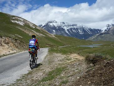
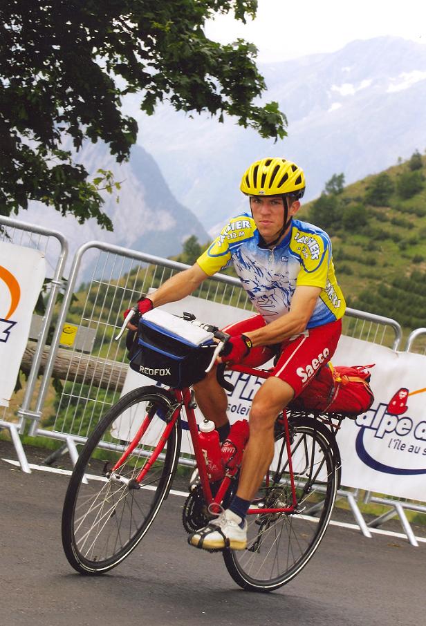
13th June, 2011, Whit Monday – 3rd tour day : St. Laurent du Var – Nizza – Isola (camping) – Col de la Lombarde (2350 m) – Santuario St Anna (2010 m) – Colle della Lombarda (2350 m) – Isola = 156,4 km + 3168 m heightdifference (4995 kcal !)
One of the most memorable day of my cyclotouring career was 24th July, 2008, when I cycled from sealevel to the 2802 m high la Bonette by my bicycle carrying 25kg weighted panniers on it. In 2011, on that day I planned a similar, but lighter one: cycling from Nice to Isola, set up my tent there, then up to Col de la Lombarde (that I had already cycled in 2005) to ascend a 2km long italian climb: Santuario St Anna (2010 m), and then back to France, Isola.
Despite it was Whit Monday, some shops, bakeries were open, so I didn’t have any problems to buy enough food. In the morning I was cycling on the lightly ascending nice valley of the Tinee stream, river, sometimes through narrow canyons, rockwalls. I indulged in nostalgia, because I like this valley and I cycled there for the 3rd time in my life. After setting up my tent in Isola (873 m) I started to cycle up to Col de la Lombarde by pleasant weather that unfortunately changed worse at the half of the ascent. I stopped for the half an hour long rain, but then the landscape, with some clouds between the mountains were beautiful.
Sometimes I heard the voices of thunders as I twisted and turned on the serpentine road. The last 4 km was an interesting section, because it was closed, but I thought that couldn’t be done because of the snow, because the snow had already melted. 1 km before the top I was just cycling upwards when I caught sight of a chamois. I just started to record it for my videocamera, when I noisy biker arrived on the closed road and made the chamois run away. I was very angry for that biker; that situation confirmed why I hate the motorbikers very much: they are noisy, too fast and disturb the nature. (few seconds about the chamois can be seen on my video)
Reaching the top (2350 m), I saw a sign, why the road was closed: road construstion was done on the italian side, but it seemed to be finished. An hour later, when I ascended back to Col de Lombarde (2350 m) the italian sign about the col showed: „Open”. The situation was funny. The french informed me that it was closed, but the italians finished the works, so they informed me, that the road was open. I got a wonderful view to the italian side from the col, because clouds came upwards from the valley, but it covered only the left half of the valley. After few kilometers descending I started to climb the missing 2 km long ascent to Santuario St Anna (2010 m), when it started raining heavily. I stopped for a while by the monastery, so when I left it, the rain was away, to start again an hour later. When I was cycling backards to Lombarde, as I looked back, the lights were turned on at the monastery and orange lights mixed with red on the sky above the mountains. I descended on the french side of Colle Lombarda (2350 m) in total darkness and by rain again. For 2-3 km long I had to be careful because of the fog, so it was an adventurous descent. I went to sleep after midnight.
Video & map about the "Lombarda & Santuario St Anna" day
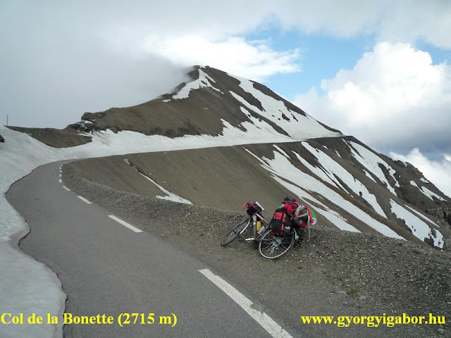
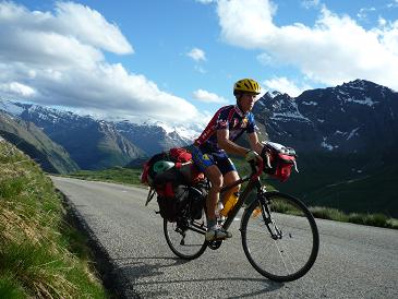
14th of June, 2011 – 4th touring day: Isola – St Etienne de Tinee – Cime de la Bonette (2802 m) – Jausiers = 73,2 km + 2010 m heightdifference (2681 kcal)
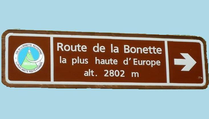
Although the Cime de la Bonette or La Bonette (2802 m) isn’t officially the highest paved road of the Alps (that is: Ötztaler Gletscherstrasse (2829 m), but arriving at the top of the Bonette climb, that is a place, where the cyclist feel on a paved road, that it could be the highest in the Alps, because looking around most of the mountains are situated at eyelevel or lower than it and nothing disturbs the wonderful panorama. Furthermore nice memorial tablet welcomes the cyclists (and tourists).
In 2008 I felt more than „only” reaching that nice place, because I started the day by Nice, at sealevel. Because of the calm nature, nice landscape and not too many motorbikers this passroad is between my favourites. It’s a long, but not too difficult ascent, there is hardly any section, where it is steeper than 8% before the 2715m col, but the last km to the 2802m high situated point is 12-14% steep.
I prepared for the day, that again I would experience unforgettable hours, and beside I would say goodbye to this road too, because after completing my collection of the paved roads above 2000 m in the Alps (as I did it in the Pyrenées in 2010), I decided to spent less time on cycling than until the year 2011. With this aim, I wanted to have the longest list on the internet about cycled paved roads in the Alps (longer than salite.ch / quaeldich.de, etc.). Since then I shared 9 profiles / diagrams about „2000+” roads with salite.ch and 4 with quaeldich.de, but I will add minimum 3 more.).
In the French Alps that was my farewell tour (last 2-3 week long tour) in the Alps, and Bonette is one my favourite. Through the day I often indulged in nostalgia: by the main square of St Etienne de Tinee, by the big waterfall, etc. By the houses of Bousiéyas it started raining, just when I could go under the roof of a house with steps to sit on and ate something. I wasn’t happy with the weather, but after a time I thought optimistic that after the rain, the partly cloudy weather could result in wonderful cycling experiences. And it happened: small clouds chased each other lighted by some sunlights. Sometimes I cycled 1-2 kms in clouds, but coming out from it or after, they were blown away by the wind. I enjoyed the wonderful lights between small racks. The passroad was opened for the traffic weeks ago, so I was surprised when I arrived at the saddle and the roundroad („collar”) wasn’t cleaned because it wasn’t necessary to travel to North, to Jausiers. The Western side were little bit more covered by snow than the Eastern side, where I could cycle up with walking by the edge of the road and snow only 2 times for ca. 50-80 meters long. I have cycled up to the 2802m high La Bonette for the 5 times in my life and that was the 3rd times when I reached it by heavy panniers on my bicycle.
I rolled down to Jausiers with enjoying the wonderful lights. I set up my tent by sunset; I had a not too hard, but memorable day.
Video & map about the "Bonette (2802 m) day"
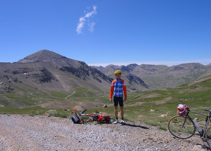
15th June, 2011 – 5th touring day: Jausiers – Barcelonnette – Col d’Allos (2250 m) – Allos – Parking du Laus, 2110 m (Lac du Allos can be reached by walking) - Allos – Col d’Allos (2250 m) – Jausiers – Col du Vars (2111 m) – Guillestre = 150,8 km + 3836 m heightdifference (4433 kcal)
I woke up for one of the hardest day of this bicycle tour: first with only a small pack ascending to Col d’Allos (2250 m), that I visited last time in 2004, then to cycle up to Parking du Laus (2110 m) from Allos village then back to Jausiers through the Col d’Allos again. After these climbs in the evening I wanted to ride my bike up to Col du Vars (2109 m), so to have a lighter day after it. I preferred to do that instead of the following day, on the day, when I had to visit the steep Col d’Izoard and another road above 2000 m.
Last time I climbed Col d’Allos from South int he year 2004, so in this year (2011) I did it from North, the more interesting, more exciting side. Opposite of the road’s beautiful landscape the col isn’t nice enough, the much less views are not so interesting. On the ascent there were great views to the Cayolle valley or to the mountains behind Barcelonnette and at last to the surroundings of the saddle.
From Allos village I started the climb to Parking du Laus under scorching sunshine between houses sparsely on the mountainside or meadows, but at halfway darker clouds arrived from West. The last 3 kms of the climb – with its 10-14% steepness was hard enough.
There wasn’t too much views from the parking place, so I spent there only a few minutes and rolled back to the village. In Allos I had just finished my lunch from my food when the I felt the first raindrops on my skin. I pushed the pedals towards the Col d’Allos by pleasantly warm weather with drizzling or light rain that didn’t cooled the air too much. At a time I felt I could take off my rainjacket and raintrousers, but not much time later I had to put on again and both happened again later. I was fed up with putting on or taking off the clothes and wasting the time for it.
On the northern side I returned back to Jausiers by little bit better weather; fortunately my washed clothes remained dry. I broke the camp as fast as I could (inside 20 minutes) and kept on cycling, but from then with carrying the 26 kgs weighted panniers and with more than 110 kms and 2900 heightdifference in my legs.
I rode my bicycle on Col du Vars for the 4th time; two of them I had reached the top by bright sunsine, the other had been happened by sunset. I was sure, that after that evening the result would be equal: I would arrive at the top after 10 pm. I prepared my spirit for the steep kilometers, for struggling because of the panniers.
It wasn’t a bed of roses, but without any traffic I enjoyed to be alone with struggling on the 9-10% steepness. I applied the usual method: I set an aim, defined a point where to I had to bear cycling, and then I extended the distance with further 200 meters or so. I reached the Col du Vars (2109 m) in total darkness at 10.20 pm. I put on enough warm clothes, a winter cap, took a picture, recorded video and then I descended to Guillestre on the pleasant road without any traffic. In Guillestre I enjoyed having enough memories to find the right camping; its name seemed to be known for me. During all of the tour I enjoyed very much that on the majority of the tour I found memories from my previous tours: I cycled here and there too, etc. I reached that level of cyclotouring in the French Alps, as I had been with the slovakian mountains after my fifth bicycletour to the High Tatras and back: I cycled in most of the noticable valleys, ascents of the French Alps; the majority of it I knew like the palm of my hand. Feeling this in the country of the Tour de France is a great experience. I went to sleep after 1 am; I finished a long, but great day again.
Video & map of the day with Col d'Allos, Parking du Laus, Col du Vars
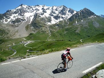
16th June, 2011 – 6th touring day: Guillestre – Col d’Izoard (2361 m) – Cervieres – towards Les Fonts (after it became dirt road) – Briancon = 64,2 km + 1664 m heightdifference (2127 kcal)
In the morning in Guillestre, while I checked the weather forecast (great weather for this day, and party rainy-sunny for the following day) a group with 40-60 cyclists arrived at the center. In June, before the high season! I started to approach the ascent of the legendary Col d’Izoard (2361 m) along the Guil stream by bright sunshine. Despite of the higher cols of my tour that I cycled with panniers on my bicycle, this was the steepest mountain road of this bicycle tour (with 9-10% steep kilometers at the 2nd half) that I ascended with panniers on my bike.
The traffic was detoured for a narrow mountainroad, not to use a 3-4 kms long section of the main road. First I didn’t felt happy with it, but as I realized the wonderful views back or ahead, down to the valley I felt it well. I enjoyed this detour. Not much before turning left to the Col d’Izoard I was overcome by a cyclist on a light bike, who told me his appreciation to me about cycling up to cols by such a bike + packs. The ascent became 9-10% steep after the houses of la Chalp. Sometimes I stopped for few minutes for taking photos or recording video.
I waited for a memorable haipin bend, that I remembered very well: in the year 2004 I took there a great photo about a cyclist and the steep bend. Unexpectedly grey clouds arrived and only less than an hour later it started raining by the panoramic Casse Desert (2210 m). From there the bare mountainside can be seen with the moraine and the Col d’Izoard with the background.
Because of the rain, unfortunately I couldn’t use my videocamera during cycling in the last 2 kms. By the saddle I was waiting for a time under a roof when „good-weather-cyclists” arrived and sat into a warm car that waited them to travel further in the car. I don’t call them serious cyclists: that’s not true cyclotouring! It’s not the same performance / effort than cycling under the clouds, sky, sunshine, rain, by each tyoe of weather. The descent was similar to my south descending in 2008, when I had to use my schoes to help me in breaking, because the cycle’s brakes weren’t enough useful. The northern ascent wasn’t so brutal and my brakes were better, so I could descent without any problems, but unfortunately my schoes got water, although I wore gaiter above my schoes. I cycled 3rd times the Col d’Izoard and I got rain for the 3rd time.
After waiting for a bit, I turned right by Cervieres and followed the sign: Les Fonts, which is situated above 2000m. The road became dirt road after less than 2 kms, so I kept on cycling for nearly a kilometer, but as it didn’t change I turned back: it isn’t a paved ascent!
In Briancon I bought some food and cakes for making my mood better:) Sometimes I felt pessimistic (Why does it rain every day? I would like to have sunny days!), but as I realised this, I tried to change my mind: „Look the better side of the occurents! In this day I could fulfill my main aims: to visit the scheduled roads, climbs going above 2000m.” They were truely important, the others not so: they are only „bonuses”, or icing on the cake.
I set up my tent in a camp that I had already known from a former bicycle tour. Using the internet point I checked the weather forecast and then went to sleep soon.
Video & map of the day with Col d'Izoard
17th June, 2011 – 7th touring day: Briancon - Chalet Laval (2030 m) – Briancon = 72,8 km + 877 m heightdifference (1448 kcal)
However the day didn’t start with a warm, but even with a cool, but sunny morning, I enjoyed the blue sky and could start cycling and looking around a little bit in Briancon wearing short cycling trousers and bicycling jersey. In the old city center, in the castle I was surprised to find a memorial tablet about a famous italian, Tour de France cyclist on the wall of the castle. Gino Bartali won 2 times the Tour de France and won 3 stages in Briancon, I think the latter was the reason why a memorial tablet was taken there. But I had to notice it was a surprise for me: about a foreign rider in France ! That showed me, how important and what means the Tour de France for the country.
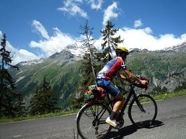
I cycled on a lightly ascending climb to East and for another few kilometers further after I turned to North, into the Valée de Clarée towards the next climb (Chalet Laval) finishing above 2000 m. The valley wasn’t so interesting, so I used music listening againt boredom. The landscape became beautiful only for the last 11 kms, after I left Nevaché. From there the road became a narrower mountain road that went ahead some forest houses; these part of the valley was good place for picnicking.
Although by quaeldich.de website the climb’s name is Chalet Laval and the height is 2015 m, in fact the end of the pavement is at 2030 m, because of little bit before the end there is a small junction, from where a short road goes to Chalet Laval. By the parking place I realized that it should be a good place for mountaineers; the steep and rocky mountains remembered me for the italian Dolomites.
Cycling backwards I felt that the weather was colder than in the morning and the the majority of the sky was covered by clouds, so in Nevaché I decided to put on long trousers. Half an hour later it started raining. First I tried to leave behind me it with a faster speed, but few minutes later I had to accept it and take place under the roof of a bus stop. My other schoes were wet in the camping, so those were my last dry schoes, that I was wearing, and that caused that I didn’t take the risk of cycling in rain, even using something to cover my schoes. After I spent 3 hours there and wrote my notices, the rain stopped for a while, so I could cycle back to Briancon and then to the camping, where I used the internet point to get informations about the weather forecast. Rain was forecasted until 2 pm. on the following day, but after then sunny afternoon and days were forecasted. It seemed that I could have a great, bright sunny day (on the day after the following day) when the legendary and beautiful Col du Galibier was scheduled.

 My english site
 Travelogue 2nd part


